

Infrared Roof Scanning
Thermal infrared roof scanning for Charlotte commercial buildings - drone and ground-level IR surveys that locate wet insulation and hidden moisture without core sampling across Mecklenburg County.
Commercial Roofers Charlotte
Infrared Roof Scanning gives owners a clearer way to compare roof conditions, budget timing, warranty requirements, and repair priorities.
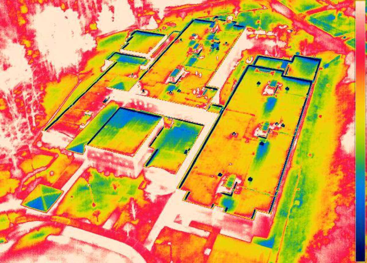
Thermal infrared scanning detects wet insulation in the roof assembly by capturing the heat it retains after the roof surface cools at dusk. We use drone IR surveys across the Charlotte metro to screen large commercial roof areas and direct core sampling to the locations where moisture is most likely present.
Wet insulation holds solar heat after the sun goes down. Dry insulation releases it. At dusk, a thermal imaging camera looking at a commercial roof sees this difference as a temperature contrast - wet areas glow warm against the cooling dry field. That temperature differential, captured by a drone-mounted thermal camera flying the roof perimeter and field in a systematic grid pattern, produces a map of suspected wet insulation without a single core pull.
Infrared scanning is not a definitive moisture determination on its own. It is a screening tool - one that covers an entire large roof in a single evening survey and points core sampling to the areas where the probability of wet insulation is highest. A 400,000-square-foot Steele Creek distribution center would require several hundred core pulls to give comparable coverage to a single infrared scan. The practical approach is scan first, core second at confirmed anomaly locations - which is how we use IR survey in our moisture investigation workflow.
Charlotte's climate creates good infrared survey conditions for most of the year. The Piedmont's summer solar loading is intense enough to build the temperature differential that IR survey requires. The challenge in Charlotte is the narrow post-sunset window before ambient heat dissipates the differential - particularly in the humid July and August weather pattern when the overnight temperature does not drop quickly. We schedule infrared scans for late September through early May when the survey window is longer and conditions are more consistent. Summer surveys in Charlotte are not unreliable, but they require a tighter flight window and better atmospheric conditions to produce clean data.
For occupied buildings, staging, access, odor control, and tenant communication are part of the roof plan before crews arrive.
For portfolio owners, the goal is consistent documentation across properties, not a one-off opinion that cannot be compared later.
The first visit produces a practical roof record: current conditions, visible failure points, drainage notes, access concerns, and the repair or replacement path that fits the building.
Owners get a written scope that separates urgent water-control work from longer-term capital planning, so the roof decision is not made from guesswork.
The closeout package keeps the next decision clear with before photos, after photos, material notes, warranty coordination, and recommended maintenance timing.
How We Run Infrared Roof Surveys
Scheduling: IR surveys are performed in the two to three hours following sunset on a day with at least six hours of unobstructed solar gain during the preceding daytime. Charlotte's partially cloudy summer afternoons sometimes limit the solar loading needed to build adequate temperature differential. We check the forecast 48 hours ahead and reschedule if cloud cover during the day is likely to compromise the scan quality. A survey performed on a day with inadequate solar loading produces a map that misses wet areas - and an IR survey that misses wet areas is more dangerous than no survey.
Drone equipment: Our drone IR surveys are flown with FLIR thermal cameras mounted on FAA Part 107-compliant commercial drone platforms. Part 107 operations around Charlotte Douglas International Airport and within Charlotte's Class B and Class C airspace require FAA authorization. We file and obtain the required airspace authorizations before every survey in controlled airspace - which includes most of the commercial building inventory within the I-485 ring. Charlotte's busy airspace around CLT means authorization timelines are a real planning consideration for drone IR work in the airport industrial corridor.
Ground-level IR survey: For buildings where drone access is restricted - Uptown Charlotte's high-rise office buildings, structures with FAA obstruction lighting requirements, or buildings in controlled airspace zones where drone authorization cannot be obtained on the required timeline - we run ground-level IR surveys using handheld thermal imaging cameras from the roof surface. Ground-level IR survey is slower and covers a smaller area per shift, but produces comparable data quality for the areas surveyed.
Data interpretation: Thermal anomalies on an IR scan require interpretation - not every warm area is wet insulation. Rooftop HVAC equipment, electrical conduit, drains with residual warm water, and areas where the building's interior HVAC load is concentrated can all produce thermal anomalies that are not moisture-related. We document every anomaly on the IR map and mark it as confirmed-moisture or non-moisture based on corroborating evidence from the physical inspection. Anomalies not resolved by physical inspection are flagged as requiring core verification.
IR Scanning Results That Direct Core Sampling
After the IR survey produces an anomaly map, we use that map to place core samples at confirmed and probable wet areas. The combination of IR survey plus targeted core sampling produces both the area coverage that a full core grid would require and the definitiveness of physical core measurement at the locations where moisture is most likely. For a 200,000-square-foot warehouse in the I-485 distribution corridor, this approach replaces a 60-to-80-core grid with a 10-to-15-core targeted sample - reducing the number of patches in the membrane while maintaining the accuracy of the moisture determination.
The IR anomaly map and the core results are presented together in the moisture survey report. Each anomaly location on the IR map is the project teamd to the zone diagram and linked to the core pull that confirms or rules out moisture. Where anomalies exist that were not cored - either because access was limited or because the anomaly resolved as a non-moisture heat source on physical inspection - we note the anomaly and the basis for the non-moisture determination. The report is the record that supports the recover-vs.-replace decision, the warranty claim, or the capital planning estimate.
Charlotte Buildings Where IR Scanning Adds the Most Value
Steele Creek and I-485 distribution corridor: The large-footprint buildings in this zone - 100,000 to 600,000 square feet of single-ply TPO or EPDM over metal deck - are the clearest case for drone IR survey. Core sampling at a meaningful grid density across these buildings is time-consuming and leaves hundreds of patch points in the membrane. A single evening drone survey covers the full field and points the core program to the locations that need it.
Post-storm investigation: After the 2024 Helene remnant rainfall and after significant hail events in Charlotte's secondary hail corridor, IR survey identifies moisture infiltration points that may not be visible as interior leaks for weeks or months. A post-Helene IR survey run in October and November 2024 found elevated moisture in commercial buildings across Mecklenburg County whose roofs showed no active leaking and no membrane surface damage visible from the walk. The infiltration was at flashings and penetrations that allowed water entry at intensity beyond what normal weathering produces.
Pre-acquisition screening on large Charlotte commercial assets: A drone IR survey can be completed in a single evening and produces a full-field moisture map within 48 to 72 hours. For a buyer's due-diligence team evaluating a large distribution or office building in the Charlotte metro, the IR survey is the fastest way to get a first-pass read on roof moisture condition before committing to a full core sampling program. Buildings that show no IR anomalies may not require core sampling at all - which compresses the due-diligence timeline.
How accurate is infrared roof scanning compared to core sampling?
IR scanning is a screening tool, not a definitive measurement. Studies of commercial roof moisture surveys show that IR scanning identifies 80-90% of wet insulation areas that core sampling would find, with a meaningful false-positive rate for non-moisture heat anomalies. We treat IR results as hypotheses to be confirmed by core samples at anomaly locations, not as final determinations. The combination of IR survey plus targeted core sampling produces better coverage than either method alone at a fraction of the cost of comprehensive core sampling.
Does Charlotte's climate affect the reliability of infrared roof scanning?
Yes. Charlotte's summer pattern - high ambient temperature that does not drop quickly after sunset, combined with afternoon cloud cover that can limit the day's solar loading - compresses the usable survey window and can reduce the temperature differential that IR survey depends on. Late September through early May is the best survey season in Charlotte. Summer surveys are not impossible, but they require better survey conditions and a tighter flight window. We assess the forecast before every survey and reschedule when conditions will compromise data quality.
Do you need FAA authorization to fly a drone IR survey over?
For most commercial buildings inside the I-485 ring and for all buildings within the Charlotte Douglas Airport Class B airspace, yes. FAA Part 107 commercial drone operations in controlled airspace require advance authorization through the FAA's LAANC system or through a formal waiver request. Most LAANC authorizations process within 24 to 48 hours. We file authorization as part of the survey scheduling process - building owners do not need to manage the FAA coordination. Authorization timelines are a real planning factor for surveys in the airport industrial corridor, where LAANC approval can take longer.
Need an infrared roof survey for a Charlotte commercial building?
We fly drone IR surveys and run ground-level thermal scans across the Charlotte metro - producing anomaly maps that direct core sampling and give you full-field moisture coverage without a comprehensive core grid.
Request a Written Scope